

Collecting wood at Tunstall.


Durham Lane Mill .

Chester Road corner of The Royalty.


Glebe Cleft Villas, situated on Chester Road between the ex-railway bridge and the Royalty.


Long Gone. A railway arch going through Bishopwearmouth Cemetery.Chester Road.


Stoney Lane, Southwick..

Lighthouse at the Wheatsheaf, only time it was lit up was the fire that destroyed it in the early 70's.


Hylton Ferry 1890.


Hylton from the north-side.
Hylton Ferry, again from the north.

Gill Bridge Cemetery off Hylton Road.


Silksworth Row, the Yellow Bird shop in view.

Spectacular crash on Selbourne street, how did he manage that???????
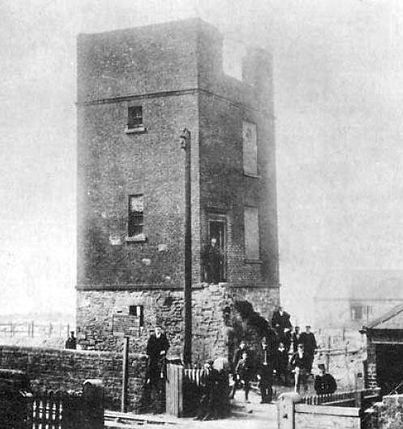

Watchtower in Lisburn Tce. The Watchtower was built in 1776 to check ship movements on a stretch of the river just above Wearmouth Bridge & demolished in 1903.

A busy crossing on the Wearmouth Bridge.
Ryhope road.

Walked away from the front of Chippies many a time.


Ford Paper Mill.
Cage Hill, Monkwearmouth.

Dame Dorothy Street, up to the 1950s.

A busy time at the top of Steels Bank.

Wheatsheaf, now Stagecoach Offices, North Bridge Street.


Mayfair toffee factory looking up Durham Road.
A broken Gill Bridge in 1934.
The hot tatie man, outside Garrick's Head Pub on Bedford Street.

Manor Quay .


Fulwell village with Ebdon's Farm circa 1910.

Sunderland's new dustcart in `1948, this design was still used in the 70's.

Bicycles and Sunderland's 'new' dustcart on The Queen Alexandra Bridge.

Waterworks Road.

Waterworks Road, Just off the back of Silksworth Row.


1985. Demolition of Waterworks Road.


This country lane is actually Chester Road, Grindon Mill pub and Penshaw Monument in the distance.
Tunstall Village.

Barnes Park Road, maybe where the old building in Barne's park is.

Belle Vue Crescent, just off Tunstall Road.

Cottage on Glass House Hill at Southwick 1949.

Dykelands Road under construction April 1936.

Dykelands Road tram lines under construction April 1936.


The end of The Ropery in Roker Avenue in the 1990s.

View of Wearmouth pit from Dame Dorothy flats.


The Royal Infirmary possibly early 1980's.
The Royal Infirmary during demolition and a damn disgrace once again. I worked there as a porter. .
Electric Clock in Newcastle Road June 1937.

Ice cream seller in Northumberland Street, now part of the Bridges.


W.T Davison Horseshoers and Blacksmiths, Monk street.
'The Galvanisers' and the railway bridge off the Pallion end of Queen Alex bridge, all gone.

Sunderland's coal-fired Power Station, Gill Bridge and Lambton Staiths Engine Shed, 1968.

Newcastle Road in August 1992. I was away in Alston when this went up.

Bishopwearmouth School .

A broader view of Bishopwearmouth School.

Grange School which was on the site of the Civic Centre.

Fulwell Mill in the distance and those houses are still there.

Newcastle Road Posh Baths. Now a little housing estate.


Southwick Green, late 19th Century.

High Southwick Board School.

Southwick Green, used to be Town Hall and dentists.

Out of work in 1935, wonder where they're sat...

Bishopwearmouth station and one hell of a brush there.

The original Echo-boy statue.


The last Victorian buildings to be demolished at Sunderland General Hospital, early 2000's.
The 'lower' Bede School and my old Alma Mater, still going .

Jackie & Davie Naisbets blacksmiths, Porterbello Lane off Roker Avenue.


Quite a narrow back lane here but where?.


West Park Central School.
Back o' the Pit Skool.


Another view of the Boys' Industrial School, East End
Boys' Industrial School, Parents waiting for their sons.


Castletown juniors school.

Hylton Road School.

Bonners Field under demolition.
Garden Street School.

St Mary's School, bottom of Chester Road.

Fulwell Mill .
A nice old lamp Sheepfolds south on the Sheepfolds.


Brewery Bank .


Dairy house in Gravesend Road and I believe it is still there,
Hall Farm, where Holborn Road met Chester Road.

Chatsworth Street, nice car, you can tell it's High Barnes .
19th century farm in Sunderland.

Canny crowd outside of Hallgarth Mission.

Bronze age canoe, once upon a time it was in our museum, the good folk at newcassel are looking after it nowadays.... ...

The cannons of Mowbray Park, went for the war effort.


Freda Street, Southwick.
Steam roller outside Fulwell Junior School.


Fulwell Road a few years ago.
Monkwearmouth station.

1947, Guisborough Street.

Dundas Street 1960 before the council 'preserved it by taking half of it away.


Train derailment at the St. Mark's/Chester Road junction.

Silksworth Row, the Yellow Bird shop in view.


Grade II-listed Word War I sound mirror at Namey Hill in Fulwell,


Train pulling into Millfield Station.
Lozenge Pill Box, Herrington, one of only two surviving.

Hylton Castle from the air.

The Millfield Station, just before closure..

Newcastle Road and some iffy driving.

And from the rear..

